

Trinity Church and Eastridge, Kannapolis, NC: A Growing Western Corridor
The Trinity Church and Eastridge area covers a broad residential corridor in western Kannapolis, North Carolina, rather than a single formally defined neighborhood. “Eastridge” is used loosely for parts of the area, which includes named subdivisions such as Trinity Crest and Trinity Crossing as well as independently developed properties along and near Trinity Church Road.
Housing ranges from older cottages, ranches and manufactured homes to custom houses on wooded acreage and newer subdivision homes. This variety gives the area a less uniform character than a typical master-planned community.
Its primary advantage is location. Residents can reach shopping in the Afton area, Interstate 85 and downtown Kannapolis without giving up the larger lots and remaining wooded land found along the corridor. Continued residential construction, transportation planning and a proposed hospital are gradually making the area more suburban.
Overall Vibe and Lifestyle
Daily life is quiet, residential and largely car-dependent. The area does not revolve around a shared clubhouse, central business district or coordinated neighborhood calendar. Instead, its character changes from one street to the next.
Newer subdivisions offer the familiar rhythm of sidewalks, streetlights, attached garages and closely spaced houses. Older properties tend to have deeper setbacks, larger yards and fewer shared standards. Some sit behind mature trees or along roads that still retain a semirural appearance.
That range suits residents who value housing choice and convenient regional access more than a unified neighborhood identity. Someone can choose a recently built home in a managed subdivision or an older property with more land while remaining in the same general part of western Kannapolis.
Walkability and Mobility
Walking is primarily recreational. Sidewalks within newer subdivisions provide practical routes for exercise and visiting neighbors, but they generally do not connect residents to stores, schools or restaurants.
Conditions become less pedestrian-oriented outside those communities. Trinity Church Road has inconsistent sidewalks, longer distances between destinations and traffic that makes walking for errands impractical. Planned transportation projects may add pedestrian infrastructure, but proposed improvements should not be treated as amenities that are already available.
A vehicle is necessary for grocery shopping, dining, medical appointments and most other daily needs. The area’s mobility advantage comes from roadway access rather than walkability.
Natural and Built Environment
The landscape shows the area’s transition from semirural land to suburban development. Mature trees, wooded edges, deep setbacks and scattered open parcels remain visible around older homes and acreage properties.
Newer subdivisions introduce a more structured environment with coordinated streets, drainage systems, streetlights and conventional suburban lots. Their smaller yards contrast with the larger parcels and irregular property layouts found elsewhere along the corridor.
Because development has occurred in separate phases, the built environment is varied rather than continuous. A wooded property or older roadside house may sit close to a recently completed neighborhood, creating visible transitions between different periods of western Kannapolis growth.
Design and Architecture
Housing styles reflect several generations of development. Older properties include cottages, brick ranches, manufactured homes and individually designed houses. These homes may have carports, detached garages, divided interior layouts and accessory structures.
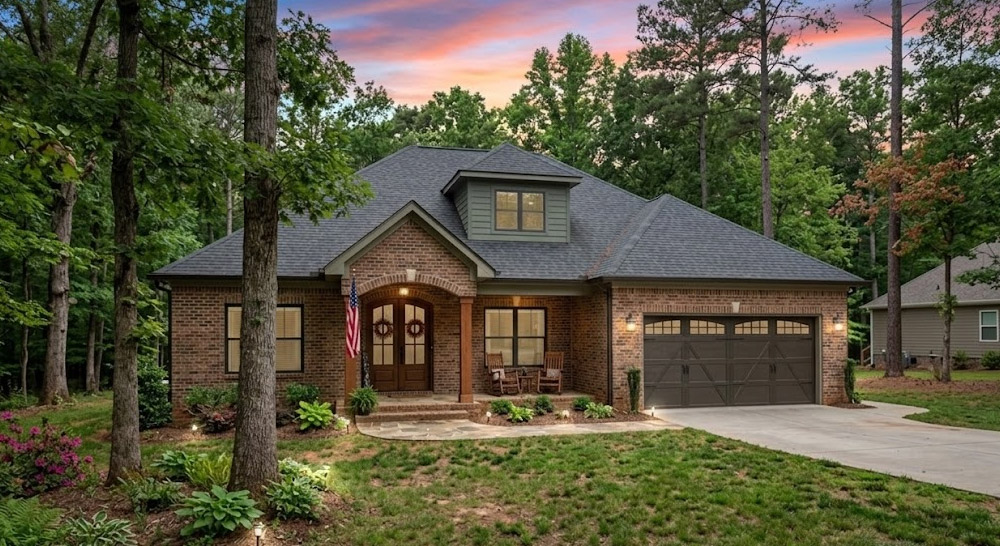
Trinity Crest, developed beginning in the late 2000s, generally features traditional and Craftsman-influenced houses with porches, gables and combinations of brick, stone and fiber-cement siding.
Trinity Crossing, built primarily during the early 2020s, has a more contemporary production-home character. Common elements include attached two-car garages, open living areas, kitchen islands, pantries and flexible rooms that may serve as offices, lofts or guest spaces.
Custom and acreage properties add another layer of architectural variety. Their designs, setbacks and outdoor features depend more on the individual parcel than on a shared neighborhood plan.
Housing at a Glance
The corridor spans nearly a century of construction, from early-20th-century homes to production subdivisions completed in the 2020s.
| Metric | Description |
|---|---|
| Property types | Older cottages and ranches, manufactured homes, custom houses, acreage properties and newer detached subdivision homes. |
| Construction period | Early and mid-20th-century homes through early-2020s construction, with major subdivision phases beginning in the late 2000s. |
| Common styles | Ranch, cottage, Craftsman-influenced, traditional and contemporary suburban. |
| Typical features | Garages or carports, porches or patios, flexible rooms and lots ranging from compact subdivision parcels to wooded acreage. |
| Community structure | Varies by property; named subdivisions may have HOAs, while many independently developed parcels do not. |
Real Estate Snapshot
The local housing market cannot be summarized as a single subdivision market. Homes differ considerably in age, lot size, utility arrangements, maintenance responsibilities and neighborhood structure.
Newer subdivision homes appeal to residents who prefer modern layouts and coordinated surroundings. Older houses may offer established landscaping, larger lots or opportunities for renovation. Custom homes and acreage properties provide greater privacy but appear less frequently.
Demand is supported by the corridor’s access to Interstate 85, western Concord and Kannapolis, along with the ability to choose among housing types that are increasingly difficult to find within one small geographic area.
| Metric | Summary |
|---|---|
| Market demand | Supported by regional access, housing variety, newer construction and the availability of larger or wooded properties. |
| Inventory | Dependent on property type and typically more limited within individual named subdivisions. |
| Housing range | Modest older homes, manufactured housing, newer subdivision residences and custom houses on acreage. |
| Pricing context | Shaped by lot size, age, renovations, utility arrangements, garages, outbuildings and subdivision location. |
| Ownership considerations | HOA responsibilities and public or private utility arrangements vary by property. |
Amenities and Local Conveniences
There are no shared amenities serving the entire Trinity Church and Eastridge area. Residents instead use nearby commercial districts, city parks and recreation facilities.
Afton Ridge is one of the closest concentrations of grocery stores, restaurants, retail and everyday services. Kellswater Commons, north of the corridor, adds a Lowes Foods supermarket along with a growing selection of dining and service businesses.
Downtown Kannapolis provides a more distinctive destination for entertainment and community activity. Atrium Health Ballpark, the Gem Theatre, the Swanee Theatre and restaurants along West Avenue give residents options beyond conventional shopping centers.
For outdoor recreation, Frank Liske Park offers a lake, fishing, paddling, playgrounds, picnic areas, athletic courts and open space. Vietnam Veterans Park provides additional walking areas, playgrounds, courts, picnic shelters, disc golf and a boardwalk through its natural areas.
Healthcare is available along the Interstate 85 corridor, including Atrium Health Cabarrus. A planned Novant Health hospital on Trinity Church Road is expected to expand medical access later in the decade, but it remains a future development rather than a current neighborhood amenity.
Schools and Education
The area is generally served by Cabarrus County Schools, even though some properties have Kannapolis mailing addresses. Likely assigned schools include Trinity Elementary School, Northwest Cabarrus Middle School and Northwest Cabarrus High School. Families should confirm assignments for the exact address using the district’s Find My School locator.
Private and charter options are available elsewhere in Kannapolis, Concord and the University City area. Nearby higher-education choices include Rowan-Cabarrus Community College, Davidson College and UNC Charlotte.
Commuting and Location
Trinity Church Road connects residents with Kannapolis Parkway, Poplar Tent Road and other routes leading toward Interstate 85. N.C. Highway 73 provides an alternative connection toward Huntersville, Davidson and the Lake Norman side of the region.
Drive times vary with traffic, construction, weather and the property’s exact location within the corridor.
| Destination | Approximate Drive Time |
|---|---|
| Afton Ridge | 5-12 minutes |
| Interstate 85 | 5-15 minutes |
| Atrium Health Cabarrus | 10-20 minutes |
| Downtown Kannapolis | 10-20 minutes |
| Uptown Charlotte | 30-50 minutes |
| Charlotte Douglas International Airport | 35-55 minutes |
Trinity Church and Eastridge Neighborhood Map
Quirks and Perks
The area’s most distinctive quality is its lack of uniformity. “Eastridge” is not a consistently defined legal neighborhood, and named subdivisions provide a more precise description when discussing a particular property. That ambiguity can be confusing, but it also reflects the corridor’s unusual mix of older homes, manufactured housing, wooded acreage and recent subdivisions.
Residents also have access to two sides of the region: Interstate 85 for Concord, University City and Charlotte, and N.C. Highway 73 for Davidson, Huntersville and Lake Norman. The trade-off is ongoing change. New housing, road projects and the planned hospital are likely to improve access while gradually reducing the corridor’s remaining semirural character.
Neighborhood Logistics
There is no single association governing the entire area. Trinity Crest, Trinity Crossing and other named subdivisions may have their own homeowners associations and common-area responsibilities, while independently developed properties may have no HOA.
Utility arrangements also differ by address, with some properties using municipal services and others relying on private systems. Parking is generally accommodated through driveways, carports or attached garages, depending on the age and type of home.
Explore Kannapolis Neighborhoods
Note on imagery: Images marked “AI Generated” are visuals to illustrate the neighborhood homes, atmosphere and architectural style. To protect homeowner privacy, these images are artistic representations and do not depict specific existing properties.

Have Questions About Moving to the Kannapolis Area?
Whether you're relocating soon or just starting to plan, drop your question here. Our internal team reads every submission and will follow up with our top local insights to help you get the real answers you need.